
ꯐꯥꯏꯜ:Algiers location.svg

Size of this PNG preview of this SVG file: ৪২৯ × ৪২৫ ꯄꯤꯛꯆꯦꯜꯁ. ꯑꯇꯩ ꯁꯦꯡꯅ ꯌꯦꯡꯕ ꯌꯥꯕ: ২৪২ × ২৪০ ꯄꯤꯛꯆꯦꯜꯁ | ৪৮৫ × ৪৮০ ꯄꯤꯛꯆꯦꯜꯁ | ৭৭৫ × ৭৬৮ ꯄꯤꯛꯆꯦꯜꯁ | ১,০৩৪ × ১,০২৪ ꯄꯤꯛꯆꯦꯜꯁ | ২,০৬৭ × ২,০৪৮ ꯄꯤꯛꯆꯦꯜꯁ.
ꯐꯥꯏꯜ ꯑꯁꯦꯡꯕ (ꯑꯦꯁ•ꯚꯤ•ꯖꯤ ꯐꯥꯏꯜ, ꯌꯥꯝꯗꯅ ৪২৯ × ৪২৫ ꯄꯤꯛꯆꯦꯜ, ꯐꯥꯏꯜ ꯆꯥꯎꯕꯒꯤ ꯆꯥꯡ: ৯ KB)
| By: |
This W3C-unspecified vector image was created with Inkscape .
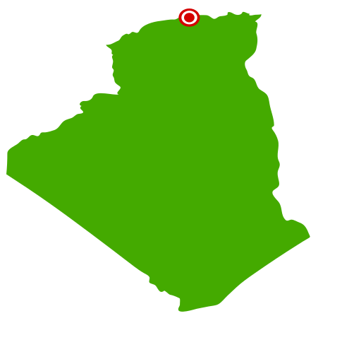
| ꯁꯟꯗꯣꯛꯅꯥ ꯇꯥꯛꯄꯥ | Vectorized map of Algeria with city locator dot | ||
| ꯆꯩꯆꯠ | (UTC) | ||
| ꯍꯧꯔꯛꯐꯛ | ꯏꯁꯥ ꯏꯊꯟꯇꯒꯤ ꯑꯣꯏꯕꯥ ꯊꯕꯛ | ||
| ꯄꯨꯊꯣꯛꯂꯤꯕ ꯃꯤ | User:Escondites | ||
| ꯑꯌꯥꯕ ꯂꯧꯕ (ꯃꯁꯤꯒꯤ ꯐꯥꯏꯜꯁꯤ ꯑꯃꯨꯛ ꯍꯟꯅꯥ ꯁꯤꯖꯤꯟꯅꯕꯥ) |
|
ꯐꯥꯏꯜꯒꯤ ꯄꯨꯋꯥꯔꯤ
ꯆꯩꯆꯠ/ꯃꯇꯝꯗ ꯅꯝꯃꯨ ꯃꯇꯝ ꯑꯗꯨꯗ ꯐꯥꯏꯜ ꯑꯗꯨ ꯎꯅꯕ
| ꯆꯩꯆꯠ/ꯃꯇꯝ | ꯈꯨꯠꯄꯤꯈꯨꯖꯤꯟ | ꯄꯥꯛ ꯆꯥꯎꯕꯥ | ꯁꯤꯖꯤꯟꯅꯔꯤꯕ | ꯑꯄꯥꯝꯕ ꯐꯣꯡꯗꯣꯛ ꯎ | |
|---|---|---|---|---|---|
| ꯍꯧꯖꯤꯛꯀꯤ | ꯱꯶:꯴꯸, ꯱꯱ ꯖꯥꯅꯨꯋꯥꯔꯤ ꯲꯰꯰꯷ | | ৪২৯ × ৪২৫ (৯ KB) | Escondites | {{User:Escondites/by}} {{Template:Inkscape}} <br> {{Information| |Description=Vectorized map of Algeria with city locator dot |Source=Myself |Date=20:50, 3 January 2007 (UTC) |Author= User:Escondites |Permission={{PD-self}} |other_versions= } |
ꯐꯥꯏꯜꯒꯤ ꯁꯤꯖꯤꯟꯅꯐꯝ
ꯃꯇꯨꯡ ꯏꯟꯕ 2ꯂꯃꯥꯏ ꯁꯤꯖꯤꯟꯅꯕ ꯃꯁꯤꯒꯤ ꯐꯥꯏꯜ:
ꯃꯥꯂꯦꯝꯒꯤ ꯊꯥꯛꯇꯥ ꯁꯤꯖꯤꯟꯅꯕꯥ ꯐꯥꯏꯜ
ꯃꯁꯤꯒꯤ ꯐꯥꯏꯜ ꯑꯁꯤ ꯃꯈꯥꯒꯤ ꯑꯇꯩ ꯋꯤꯀꯤꯁꯤꯡꯅ ꯁꯤꯖꯤꯟꯅꯩ:
- af.wikipedia.org ꯗꯥ ꯁꯤꯖꯤꯟꯅꯩ
- ceb.wikipedia.org ꯗꯥ ꯁꯤꯖꯤꯟꯅꯩ
- cs.wikipedia.org ꯗꯥ ꯁꯤꯖꯤꯟꯅꯩ
- da.wikipedia.org ꯗꯥ ꯁꯤꯖꯤꯟꯅꯩ
- de.wikinews.org ꯗꯥ ꯁꯤꯖꯤꯟꯅꯩ
- en.wikipedia.org ꯗꯥ ꯁꯤꯖꯤꯟꯅꯩ
- en.wikinews.org ꯗꯥ ꯁꯤꯖꯤꯟꯅꯩ
- fo.wikipedia.org ꯗꯥ ꯁꯤꯖꯤꯟꯅꯩ
- hif.wikipedia.org ꯗꯥ ꯁꯤꯖꯤꯟꯅꯩ
- io.wikipedia.org ꯗꯥ ꯁꯤꯖꯤꯟꯅꯩ
- jv.wikipedia.org ꯗꯥ ꯁꯤꯖꯤꯟꯅꯩ
- oc.wikipedia.org ꯗꯥ ꯁꯤꯖꯤꯟꯅꯩ
- pt.wikipedia.org ꯗꯥ ꯁꯤꯖꯤꯟꯅꯩ
- simple.wikipedia.org ꯗꯥ ꯁꯤꯖꯤꯟꯅꯩ
- su.wikipedia.org ꯗꯥ ꯁꯤꯖꯤꯟꯅꯩ
- wo.wikipedia.org ꯗꯥ ꯁꯤꯖꯤꯟꯅꯩ
- yi.wikipedia.org ꯗꯥ ꯁꯤꯖꯤꯟꯅꯩ
- zh-yue.wikipedia.org ꯗꯥ ꯁꯤꯖꯤꯟꯅꯩ
- zh.wikipedia.org ꯗꯥ ꯁꯤꯖꯤꯟꯅꯩ