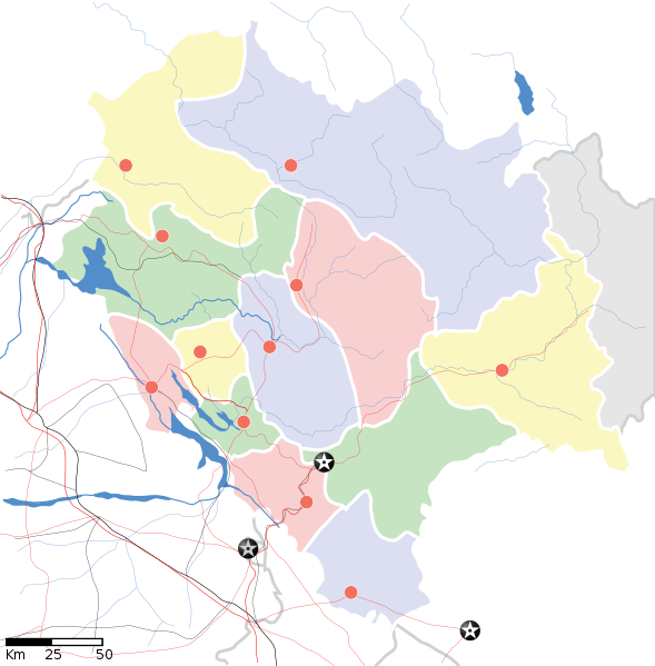
ꯐꯥꯏꯜ:Himachal Pradesh locator map.svg
Page contents not supported in other languages.
ꯋꯤꯀꯤꯄꯦꯗꯤꯌꯥ ꯗꯒꯤ

ꯐꯥꯏꯜ ꯑꯁꯦꯡꯕ(ꯑꯦꯁ•ꯚꯤ•ꯖꯤ ꯐꯥꯏꯜ, ꯌꯥꯝꯗꯅ ১,০৩৯ × ১,০৫৭ ꯄꯤꯛꯆꯦꯜ, ꯐꯥꯏꯜ ꯆꯥꯎꯕꯒꯤ ꯆꯥꯡ: ১৩৮ KB)

ꯃꯁꯤꯒꯤ ꯐꯥꯏꯜ ꯑꯁꯤ Wikimedia Commons ꯗꯒꯤꯅꯤ ꯑꯃꯁꯨꯡ ꯑꯇꯩ ꯊꯧꯔꯥꯁꯁꯤꯡꯅꯥ ꯁꯤꯖꯤꯟꯅꯩ ꯫ ꯃꯁꯤꯗ ꯁꯟꯗꯣꯛꯅꯥ ꯇꯥꯛꯄ ꯑꯁꯤ ꯐꯥꯏꯜ ꯁꯟꯗꯣꯛꯅꯥ ꯍꯥꯏꯕ ꯂꯃꯥꯏ ꯃꯈꯥꯒꯤ ꯁꯤꯗ ꯎꯨꯠꯂꯦ ꯫

Title
Himachal Pradesh locator map
Description
Map of w:Himachal Pradesh with road and rail lines. Equirectangular projection. Geographic limits of the map: top=33.31, bottom=30.16, left=75.39, right=79.05.
ꯆꯩꯆꯠ
ꯍꯧꯔꯛꯐꯛ

ꯏꯁꯥ ꯏꯊꯟꯇꯒꯤ ꯑꯣꯏꯕꯥ ꯊꯕꯛ
International Borders: University of Texas map library - India Political map 2001
Disputed Borders: University of Texas map library - China-India Borders - Eastern Sector 1988 & Western Sector 1988 - Kashmir Region 2004 - Kashmir Maps.
State and District boundaries: Census of India - 2001 Census State Maps - Survey of India Maps.
Other sources: US Army Map Service, Survey of India Map Explorer, Columbia University

Map specific sources: .
Creator
This Image was created by User:PlaneMad.
  • If you are using the image under the creative commons share alike license please credit the photo CC-by-sa PlaneMad/Wikimedia and include a link to this page. No explicit permission is needed from me, but id appreciate an email if my work has been of help to you.
  • If you dont want to release your work under a creative commons license, please mail me at arun.planemad@gmail.com or catch me at my Website to negotiate a custom license as per your needs.
ꯑꯌꯥꯕ ꯂꯧꯕ
(ꯃꯁꯤꯒꯤ ꯐꯥꯏꯜꯁꯤ ꯑꯃꯨꯛ ꯍꯟꯅꯥ ꯁꯤꯖꯤꯟꯅꯕꯥ)
I, the copyright holder of this work, hereby publish it under the following license:
w:en:Creative Commons
ꯈꯣꯝꯒꯠꯂꯛꯄꯥ ꯃꯥꯟꯅꯕꯥ ꯁꯥꯔꯨꯛ
ꯐꯥꯏꯜ ꯑꯁꯤ ꯀ꯭ꯔꯤꯌꯦꯇꯤꯚ ꯀꯣꯃꯣꯟꯁꯀꯤ Attribution-Share Alike 3.0 Unported ꯑꯌꯥꯕꯒꯤ ꯃꯈꯥꯗ ꯌꯥꯎꯕꯅꯤ ꯫
ꯅꯪꯒꯤ ꯀꯨꯁꯤ:
  • ꯃꯌꯥꯝꯗꯥ ꯐꯪꯍꯟꯕꯥ – ꯊꯥꯕꯛ ꯑꯗꯨ ꯁꯤꯟꯖꯤꯟꯕꯥ, ꯌꯦꯟꯊꯣꯛ ꯎ ꯑꯃꯥꯗꯤ ꯃꯐꯝ ꯱ ꯗꯥ ꯆꯠꯍꯟꯂꯨ
  • ꯑꯃꯨꯛꯀꯥ ꯌꯥꯟꯁꯤꯟꯅꯍꯟꯕꯥ – ꯊꯥꯕꯛꯇꯨꯒꯥ ꯆꯨꯁꯤꯟꯅꯍꯟꯕꯥ
ꯃꯈꯥꯒꯤ ꯌꯥꯅꯕꯒꯤ ꯃꯈꯥ ꯄꯣꯟꯅ:
  • ꯈꯣꯝꯒꯠꯂꯛꯄꯥ – ꯅꯪꯅ ꯆꯞꯆꯥꯕ ꯇꯧꯕꯤꯃꯜ ꯄꯤꯕꯤꯒꯗꯕꯅꯤ, ꯑꯌꯥꯕ ꯄꯤꯔꯤꯕꯁꯤꯡꯒ ꯁꯝꯅꯐꯝ ꯄꯤꯒꯗꯕꯅꯤ ꯑꯃꯁꯨꯡ ꯑꯍꯣꯡꯕ ꯈꯔꯥ ꯂꯩꯔꯗꯤ ꯃꯗꯨ ꯎꯠꯀꯗꯕꯅꯤ ꯫ ꯅꯪꯅ ꯃꯗꯨ ꯃꯔꯝ ꯂꯩꯅ ꯇꯧꯒꯗꯕꯅꯤ, ꯑꯗꯨꯕꯨ ꯑꯌꯥꯕ ꯄꯥꯏꯔꯤꯕꯗꯨꯅ ꯍꯥꯏꯔꯛꯄ ꯃꯑꯣꯡ ꯅꯠꯇ꯭ꯔꯒ ꯅꯪꯅ ꯁꯤꯖꯤꯟꯅꯕ ꯃꯑꯣꯡꯗ ꯇꯧꯔꯣꯏꯗꯕꯅꯤ ꯫
  • ꯃꯥꯟꯅꯕꯥ ꯁꯥꯔꯨꯛ – ꯀꯔꯤꯒꯨꯝꯅ ꯅꯪꯅ ꯌꯥꯟꯁꯤꯟꯅꯔꯕ, ꯍꯣꯡꯗꯣꯛꯍꯟꯂꯕ, ꯅꯠꯇ꯭ꯔꯒ ꯄꯣꯠꯆꯪꯁꯤꯡ ꯁꯥꯒꯠꯂꯕꯗꯤ, ꯅꯪꯒꯤ ꯍꯣꯠꯅꯖꯃꯟ ꯑꯗꯨ ꯃꯁꯤꯒꯤ same or compatible licenseꯒꯤ
ꯃꯈꯥꯗ ꯎꯠꯀꯗꯕꯅꯤ ꯑꯁꯦꯡꯕ ꯑꯅꯧꯕ ꯱ ꯑꯣꯏꯅ ꯂꯧꯗꯨꯅ ꯫

The frontiers depicted on the Indian maps in Wikipedia are from a neutral point of view and may differ from official government maps of India, Pakistan and China. Please consult local laws governing publication of maps before usage.
 Geotemporal data
Date depicted second half of 20 century ꯑꯃꯁꯨꯡ 21 century
Georeferencing Georeference the map in Wikimaps Warper If inappropriate please set warp_status = skip to hide.
 Archival data
Notes Part of WikiProject India Maps
Other versions Derivative works of this file:  Himachal Pradesh locator map2.svg

Captions

Add a one-line explanation of what this file represents
Barog

Items portrayed in this file

depicts ইংলিস

copyright status ইংলিস

copyrighted ইংলিস

source of file ইংলিস

MIME type ইংলিস

image/svg+xml

ꯐꯥꯏꯜꯒꯤ ꯄꯨꯋꯥꯔꯤ

ꯆꯩꯆꯠ/ꯃꯇꯝꯗ ꯅꯝꯃꯨ ꯃꯇꯝ ꯑꯗꯨꯗ ꯐꯥꯏꯜ ꯑꯗꯨ ꯎꯅꯕ

ꯆꯩꯆꯠ/ꯃꯇꯝꯈꯨꯠꯄꯤꯈꯨꯖꯤꯟꯄꯥꯛ ꯆꯥꯎꯕꯥꯁꯤꯖꯤꯟꯅꯔꯤꯕꯑꯄꯥꯝꯕ ꯐꯣꯡꯗꯣꯛ ꯎ
ꯍꯧꯖꯤꯛꯀꯤ꯲꯳:꯳꯶, ꯱꯴ ꯑꯦꯄꯔꯤꯜ ꯲꯰꯲꯰꯲꯳:꯳꯶, ꯱꯴ ꯑꯦꯄꯔꯤꯜ ꯲꯰꯲꯰ꯒꯤ ꯃꯇꯨꯡ ꯏꯟꯅ ꯊꯝꯅꯦꯜ ꯚꯔꯖꯟ১,০৩৯ × ১,০৫৭ (১৩৮ KB)C1MMReverted to version as of 08:30, 11 April 2016 (UTC)
꯲꯳:꯳꯵, ꯱꯴ ꯑꯦꯄꯔꯤꯜ ꯲꯰꯲꯰꯲꯳:꯳꯵, ꯱꯴ ꯑꯦꯄꯔꯤꯜ ꯲꯰꯲꯰ꯒꯤ ꯃꯇꯨꯡ ꯏꯟꯅ ꯊꯝꯅꯦꯜ ꯚꯔꯖꯟ১,৭৩৫ × ১,৭৬১ (১২৭ KB)C1MMStandardized
꯱꯴:꯰꯰, ꯱꯱ ꯑꯦꯄꯔꯤꯜ ꯲꯰꯱꯶꯱꯴:꯰꯰, ꯱꯱ ꯑꯦꯄꯔꯤꯜ ꯲꯰꯱꯶ꯒꯤ ꯃꯇꯨꯡ ꯏꯟꯅ ꯊꯝꯅꯦꯜ ꯚꯔꯖꯟ১,০৩৯ × ১,০৫৭ (১৩৮ KB)SnjsharmaReverted to version as of 16:48, 4 June 2007 (UTC)
꯱꯲:꯱꯹, ꯱꯴ ꯃꯦ ꯲꯰꯱꯳꯱꯲:꯱꯹, ꯱꯴ ꯃꯦ ꯲꯰꯱꯳ꯒꯤ ꯃꯇꯨꯡ ꯏꯟꯅ ꯊꯝꯅꯦꯜ ꯚꯔꯖꯟ২,০০০ × ২,০৩৫ (৮৫৪ KB)SnjsharmaNew Version.
꯲꯲:꯱꯸, ꯴ ꯖꯨꯟ ꯲꯰꯰꯷꯲꯲:꯱꯸, ꯴ ꯖꯨꯟ ꯲꯰꯰꯷ꯒꯤ ꯃꯇꯨꯡ ꯏꯟꯅ ꯊꯝꯅꯦꯜ ꯚꯔꯖꯟ১,০৩৯ × ১,০৫৭ (১৩৮ KB)Planemad{{WikiProject_India_Maps |Title=Himachal Pradesh locator map |Description=Map of w:Himachal Pradesh with road and rail lines. |Source= |Date=June 2007 |Author=w:user:Planemad }} Category:WikiProject India State Maps

ꯃꯁꯤꯒꯤ ꯐꯥꯏꯜ ꯁꯤ ꯁꯤꯖꯤꯟꯅꯕ ꯂꯃꯥꯏꯁꯤꯡ ꯂꯩꯇꯦ ꯫

ꯃꯥꯂꯦꯝꯒꯤ ꯊꯥꯛꯇꯥ ꯁꯤꯖꯤꯟꯅꯕꯥ ꯐꯥꯏꯜ

ꯃꯁꯤꯒꯤ ꯐꯥꯏꯜ ꯑꯁꯤ ꯃꯈꯥꯒꯤ ꯑꯇꯩ ꯋꯤꯀꯤꯁꯤꯡꯅ ꯁꯤꯖꯤꯟꯅꯩ:

ꯌꯦꯡꯉꯨ ꯃꯂꯦꯝꯒꯤ ꯊꯥꯛꯀꯤ ꯁꯤꯖꯤꯟꯅꯐꯝ ꯑꯗꯨ ꯃꯁꯤꯒꯤ ꯐꯥꯏꯜꯁꯤꯗ ꯫

ꯃꯦꯇꯥꯗꯥꯇꯥ

"https://mni.wikipedia.org/wiki/ꯐꯥꯏꯜ:Himachal_Pradesh_locator_map.svg" ꯃꯐꯝꯗꯨꯗꯒꯤ ꯂꯧꯈꯠꯂꯛꯄꯥ