
ꯐꯥꯏꯜ:Aerial photo of the Andes.jpg
ꯃꯁꯤꯒꯤ ꯄ꯭ꯔꯚꯤꯌꯨ ꯑꯁꯤꯒꯤ ꯁꯥꯏꯓ: ৪৮৪ × ৫৯৯ ꯄꯤꯛꯆꯦꯜꯁ. ꯑꯇꯩ ꯁꯦꯡꯅ ꯌꯦꯡꯕ ꯌꯥꯕ: ১৯৪ × ২৪০ ꯄꯤꯛꯆꯦꯜꯁ | ৩৮৭ × ৪৮০ ꯄꯤꯛꯆꯦꯜꯁ | ৬২০ × ৭৬৮ ꯄꯤꯛꯆꯦꯜꯁ | ১,০৪৮ × ১,২৯৮ ꯄꯤꯛꯆꯦꯜꯁ.
ꯐꯥꯏꯜ ꯑꯁꯦꯡꯕ (১,০৪৮ × ১,২৯৮ ꯄꯤꯛꯆꯦꯜꯁ, ꯐꯥꯏꯜ ꯆꯥꯎꯕꯒꯤ ꯆꯥꯡ: ১,০০৭ KB, MIME ꯃꯈꯜ: image/jpeg)
ꯑꯇꯦꯟꯕꯥ ꯁꯟꯗꯣꯛꯅꯥ ꯇꯥꯛꯄꯥ
| ꯁꯟꯗꯣꯛꯅꯥ ꯇꯥꯛꯄꯥ |
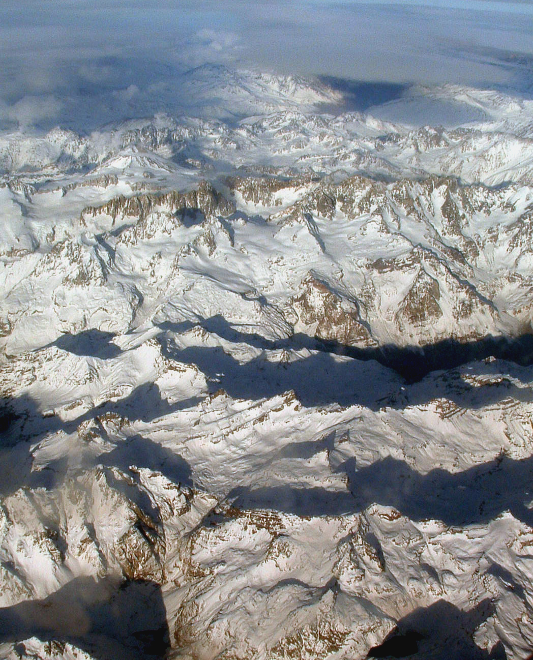
English: The Andes. Photo was taken on a flight between Asuncion, Paraguay and Santiago, Chile, so the exact location is probably in the area between Santiago, Chile and Cordoba, Argentina. |
| ꯆꯩꯆꯠ | |
| ꯍꯧꯔꯛꯐꯛ | Wikipedia:Contact us/Photo submission |
| ꯄꯨꯊꯣꯛꯂꯤꯕ ꯃꯤ | Robert Morrow |
| ꯑꯌꯥꯕ ꯂꯧꯕ (ꯃꯁꯤꯒꯤ ꯐꯥꯏꯜꯁꯤ ꯑꯃꯨꯛ ꯍꯟꯅꯥ ꯁꯤꯖꯤꯟꯅꯕꯥ) |
ꯐꯥꯏꯜ ꯑꯁꯤ ꯀ꯭ꯔꯤꯌꯦꯇꯤꯚ ꯀꯣꯃꯣꯟꯁꯀꯤ Attribution-Share Alike 3.0 Unported ꯑꯌꯥꯕꯒꯤ ꯃꯈꯥꯗ ꯌꯥꯎꯕꯅꯤ ꯫
|
| Other versions | Derivative works of this file: Palomo.jpg |
| Object location | | View this and other nearby images on: OpenStreetMap |
|---|
| Annotations | This image is annotated: View the annotations at Commons |
ꯐꯥꯏꯜꯒꯤ ꯄꯨꯋꯥꯔꯤ
ꯆꯩꯆꯠ/ꯃꯇꯝꯗ ꯅꯝꯃꯨ ꯃꯇꯝ ꯑꯗꯨꯗ ꯐꯥꯏꯜ ꯑꯗꯨ ꯎꯅꯕ
| ꯆꯩꯆꯠ/ꯃꯇꯝ | ꯈꯨꯠꯄꯤꯈꯨꯖꯤꯟ | ꯄꯥꯛ ꯆꯥꯎꯕꯥ | ꯁꯤꯖꯤꯟꯅꯔꯤꯕ | ꯑꯄꯥꯝꯕ ꯐꯣꯡꯗꯣꯛ ꯎ | |
|---|---|---|---|---|---|
| ꯍꯧꯖꯤꯛꯀꯤ | ꯰꯴:꯳꯱, ꯷ ꯅꯣꯚꯦꯝꯕꯔ ꯲꯰꯰꯸ | | ১,০৪৮ × ১,২৯৮ (১,০০৭ KB) | Holly Cheng | {{Information |Description={{en|1=The Andes}} |Source={{w|Wikipedia:Contact us/Photo submission}} |Author=Robert Morrow |Date=see EXIF info |Permission={{PermissionOTRS|ticket=https://secure.wikimedia.org/otrs/index.pl?Action=AgentTicketZoom&TicketID=2170 |
ꯐꯥꯏꯜꯒꯤ ꯁꯤꯖꯤꯟꯅꯐꯝ
ꯃꯇꯨꯡ ꯏꯟꯕ ꯂꯃꯥꯏꯁꯤꯖꯤꯟꯅꯕ ꯃꯁꯤꯒꯤ ꯐꯥꯏꯜ:
ꯃꯥꯂꯦꯝꯒꯤ ꯊꯥꯛꯇꯥ ꯁꯤꯖꯤꯟꯅꯕꯥ ꯐꯥꯏꯜ
ꯃꯁꯤꯒꯤ ꯐꯥꯏꯜ ꯑꯁꯤ ꯃꯈꯥꯒꯤ ꯑꯇꯩ ꯋꯤꯀꯤꯁꯤꯡꯅ ꯁꯤꯖꯤꯟꯅꯩ:
- ami.wikipedia.org ꯗꯥ ꯁꯤꯖꯤꯟꯅꯩ
- ar.wikipedia.org ꯗꯥ ꯁꯤꯖꯤꯟꯅꯩ
- arz.wikipedia.org ꯗꯥ ꯁꯤꯖꯤꯟꯅꯩ
- as.wikipedia.org ꯗꯥ ꯁꯤꯖꯤꯟꯅꯩ
- bh.wikipedia.org ꯗꯥ ꯁꯤꯖꯤꯟꯅꯩ
- bs.wikipedia.org ꯗꯥ ꯁꯤꯖꯤꯟꯅꯩ
- bxr.wikipedia.org ꯗꯥ ꯁꯤꯖꯤꯟꯅꯩ
- ca.wikipedia.org ꯗꯥ ꯁꯤꯖꯤꯟꯅꯩ
- ceb.wikipedia.org ꯗꯥ ꯁꯤꯖꯤꯟꯅꯩ
- de.wikipedia.org ꯗꯥ ꯁꯤꯖꯤꯟꯅꯩ
- dty.wikipedia.org ꯗꯥ ꯁꯤꯖꯤꯟꯅꯩ
- en.wikipedia.org ꯗꯥ ꯁꯤꯖꯤꯟꯅꯩ
- en.wikibooks.org ꯗꯥ ꯁꯤꯖꯤꯟꯅꯩ
- eo.wikipedia.org ꯗꯥ ꯁꯤꯖꯤꯟꯅꯩ
- es.wikipedia.org ꯗꯥ ꯁꯤꯖꯤꯟꯅꯩ
- fiu-vro.wikipedia.org ꯗꯥ ꯁꯤꯖꯤꯟꯅꯩ
- hy.wikipedia.org ꯗꯥ ꯁꯤꯖꯤꯟꯅꯩ
- ilo.wikipedia.org ꯗꯥ ꯁꯤꯖꯤꯟꯅꯩ
- Andes
- Kabambantayan
- Wikipedia:Napili nga artikulo ita nga aldaw/Marso 26
- Wikipedia:Umuna a Panid/Intono bigat
- Wikipedia:Napili nga artikulo ita nga aldaw/Mayo 10
- Wikipedia:Napili nga artikulo ita nga aldaw/Hunio 24
- Wikipedia:Napili nga artikulo ita nga aldaw/Agosto 8
- Wikipedia:Napili nga artikulo ita nga aldaw/Septiembre 22
- Wikipedia:Napili nga artikulo ita nga aldaw/Nobiembre 6
- Wikipedia:Napili nga artikulo ita nga aldaw/Disiembre 21
- Wikipedia:Napili nga artikulo ita nga aldaw/Pebrero 4
- io.wikipedia.org ꯗꯥ ꯁꯤꯖꯤꯟꯅꯩ
- ka.wikipedia.org ꯗꯥ ꯁꯤꯖꯤꯟꯅꯩ
- kk.wikipedia.org ꯗꯥ ꯁꯤꯖꯤꯟꯅꯩ
- ko.wikipedia.org ꯗꯥ ꯁꯤꯖꯤꯟꯅꯩ
- lld.wikipedia.org ꯗꯥ ꯁꯤꯖꯤꯟꯅꯩ
- mai.wikipedia.org ꯗꯥ ꯁꯤꯖꯤꯟꯅꯩ
- ml.wikipedia.org ꯗꯥ ꯁꯤꯖꯤꯟꯅꯩ
- mr.wikipedia.org ꯗꯥ ꯁꯤꯖꯤꯟꯅꯩ
- my.wikipedia.org ꯗꯥ ꯁꯤꯖꯤꯟꯅꯩ
ꯌꯦꯡꯉꯨ ꯃꯂꯦꯝꯒꯤ ꯊꯥꯛꯀꯤ ꯁꯤꯖꯤꯟꯅꯐꯝ ꯑꯗꯨ ꯃꯁꯤꯒꯤ ꯐꯥꯏꯜꯁꯤꯗ ꯫