
ꯐꯥꯏꯜ:World Map 1689.JPG

ꯐꯥꯏꯜ ꯑꯁꯦꯡꯕ (৪,৫৬০ × ৩,৯৩৬ ꯄꯤꯛꯆꯦꯜꯁ, ꯐꯥꯏꯜ ꯆꯥꯎꯕꯒꯤ ꯆꯥꯡ: ৮.৫৯ MB, MIME ꯃꯈꯜ: image/jpeg)
|

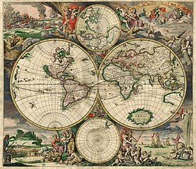
This image was selected as picture of the day on Wikimedia Commons for 7 February 2007. It was captioned as follows: English: An old world map produced in Amsterdam in 1689. Other languages:
Deutsch: Eine 1689 in Amsterdam hergestellte Weltkarte. English: An old world map produced in Amsterdam in 1689. Polski: Mapa świata wyprodukowana w Amsterdamie w roku 1689. Suomi: Hollantilainen maailmankartta vuodelta 1689 Svenska: En gammal världskarta tillverkad i Amsterdam 1689. Winaray: In kahadto nga mapa han kalibutan nga ginhimo ha Amsterdam, 1689. Српски / srpski: Стара карта света направљена у Амстердаму 1689. עברית : מפת עולם משנת 1689 מאמסטרדם |
| This image was selected as a picture of the week on the Persian Wikipedia for the ২১. week, 2011. |
ꯑꯇꯦꯟꯕꯥ ꯁꯟꯗꯣꯛꯅꯥ ꯇꯥꯛꯄꯥ
| Description |
Nederlands: Nova totius terrarum orbis tabula Amstelodami, ex officina G. a Schagen (1682), t'Amsterdam Gedruckt by G. van Schagen, by de Nieuwe Haerlemmer Sluys.
English: World map - Produced in Amsterdam
First edition : 1689. Original size : 48.3 x 56.0 cm. Produced using copper engraving. Extremely rare set of maps, only known in one other example in the Amsterdam University. No copies in American libraries. In original hand color. Français : Carte du monde - Créée à Amsterdam Première édition : 1689. Taille originale : 48,3 x 56,0 cm. Eau forte. |
| ꯆꯩꯆꯠ | This edition 1689 |
| ꯍꯧꯔꯛꯐꯛ | This image is made up of six separate images downloaded from Helmink.com and stitched together. |
| Creator | |
| ꯑꯌꯥꯕ ꯂꯧꯕ (ꯃꯁꯤꯒꯤ ꯐꯥꯏꯜꯁꯤ ꯑꯃꯨꯛ ꯍꯟꯅꯥ ꯁꯤꯖꯤꯟꯅꯕꯥ) |
Public Domain |
| Georeferencing | If inappropriate please set warp_status = skip to hide. |
| Other versions | Image:World Map 1689-smaller.jpg (smaller filesize version, easier to download) |
.JPG)
ꯑꯌꯥꯕꯥ
|
This work is in the public domain in its country of origin and other countries and areas where the copyright term is the author's life plus 70 years or fewer.
| |
| This file has been identified as being free of known restrictions under copyright law, including all related and neighboring rights. | |
ꯐꯥꯏꯜꯒꯤ ꯄꯨꯋꯥꯔꯤ
ꯆꯩꯆꯠ/ꯃꯇꯝꯗ ꯅꯝꯃꯨ ꯃꯇꯝ ꯑꯗꯨꯗ ꯐꯥꯏꯜ ꯑꯗꯨ ꯎꯅꯕ
| ꯆꯩꯆꯠ/ꯃꯇꯝ | ꯈꯨꯠꯄꯤꯈꯨꯖꯤꯟ | ꯄꯥꯛ ꯆꯥꯎꯕꯥ | ꯁꯤꯖꯤꯟꯅꯔꯤꯕ | ꯑꯄꯥꯝꯕ ꯐꯣꯡꯗꯣꯛ ꯎ | |
|---|---|---|---|---|---|
| ꯍꯧꯖꯤꯛꯀꯤ | ꯰꯶:꯲꯹, ꯴ ꯁꯦꯞꯇꯦꯝꯕꯔ ꯲꯰꯱꯳ | | ৪,৫৬০ × ৩,৯৩৬ (৮.৫৯ MB) | Crisco 1492 | Reverted to version as of 12:34, 16 October 2010 |
| ꯰꯶:꯱꯷, ꯴ ꯁꯦꯞꯇꯦꯝꯕꯔ ꯲꯰꯱꯳ |  | ৪,৫৬০ × ৩,৯৩৬ (১৯.৫৬ MB) | Crisco 1492 | Reverted to version as of 01:01, 30 November 2006 Per Commons:Overwriting existing files, do not overwrite featured images | |
| ꯱꯸:꯰꯴, ꯱꯶ ꯑꯣꯛꯇꯣꯕꯔ ꯲꯰꯱꯰ |  | ৪,৫৬০ × ৩,৯৩৬ (৮.৫৯ MB) | Brandmeister~commonswiki | slight adjustment | |
| ꯰꯶:꯳꯱, ꯳꯰ ꯅꯣꯚꯦꯝꯕꯔ ꯲꯰꯰꯶ |  | ৪,৫৬০ × ৩,৯৩৬ (১৯.৫৬ MB) | Tarawneh | == Summary == {{Information |Description= World map - Produced in Amsterdam<br> FIRST edition : 1689 <br> Original size : 48.3 x 56.0 cm <br> Produced using copper engraving |Source= scanned copy |Date= This edition 1689 |Author= van Schagen |Permission |
ꯐꯥꯏꯜꯒꯤ ꯁꯤꯖꯤꯟꯅꯐꯝ
ꯃꯇꯨꯡ ꯏꯟꯕ ꯂꯃꯥꯏꯁꯤꯖꯤꯟꯅꯕ ꯃꯁꯤꯒꯤ ꯐꯥꯏꯜ:
ꯃꯥꯂꯦꯝꯒꯤ ꯊꯥꯛꯇꯥ ꯁꯤꯖꯤꯟꯅꯕꯥ ꯐꯥꯏꯜ
ꯃꯁꯤꯒꯤ ꯐꯥꯏꯜ ꯑꯁꯤ ꯃꯈꯥꯒꯤ ꯑꯇꯩ ꯋꯤꯀꯤꯁꯤꯡꯅ ꯁꯤꯖꯤꯟꯅꯩ:
- af.wikipedia.org ꯗꯥ ꯁꯤꯖꯤꯟꯅꯩ
- ar.wikipedia.org ꯗꯥ ꯁꯤꯖꯤꯟꯅꯩ
- ba.wikipedia.org ꯗꯥ ꯁꯤꯖꯤꯟꯅꯩ
- bg.wikipedia.org ꯗꯥ ꯁꯤꯖꯤꯟꯅꯩ
- bg.wikiquote.org ꯗꯥ ꯁꯤꯖꯤꯟꯅꯩ
- bjn.wikipedia.org ꯗꯥ ꯁꯤꯖꯤꯟꯅꯩ
- bn.wikipedia.org ꯗꯥ ꯁꯤꯖꯤꯟꯅꯩ
- bs.wikipedia.org ꯗꯥ ꯁꯤꯖꯤꯟꯅꯩ
- ca.wikipedia.org ꯗꯥ ꯁꯤꯖꯤꯟꯅꯩ
- ce.wikipedia.org ꯗꯥ ꯁꯤꯖꯤꯟꯅꯩ
- crh.wikipedia.org ꯗꯥ ꯁꯤꯖꯤꯟꯅꯩ
- cs.wikipedia.org ꯗꯥ ꯁꯤꯖꯤꯟꯅꯩ
- cv.wikipedia.org ꯗꯥ ꯁꯤꯖꯤꯟꯅꯩ
- de.wikipedia.org ꯗꯥ ꯁꯤꯖꯤꯟꯅꯩ
- el.wikipedia.org ꯗꯥ ꯁꯤꯖꯤꯟꯅꯩ
ꯌꯦꯡꯉꯨ ꯃꯂꯦꯝꯒꯤ ꯊꯥꯛꯀꯤ ꯁꯤꯖꯤꯟꯅꯐꯝ ꯑꯗꯨ ꯃꯁꯤꯒꯤ ꯐꯥꯏꯜꯁꯤꯗ ꯫